Recommended
Drones
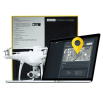
Propeller’s PPK drone surveying solution is compatible with multiple drones, but our recommended drones provide the best user experience.
")
Recommended Drones — Powered by Propeller
We get it — choosing the right drone for your survey area (and your budget) can seem overwhelming, especially if you’re new to drone surveying. That’s why we’ve made it our mission to find the best drone surveying hardware on the market. (We’ve done the research so you don’t have to!)
For high-accuracy drone surveying, there’s no better solution than PPK
All of our recommended drones are manufactured by companies that have partnered with Propeller to bring a fully integrated PPK solution to life.
Benefits of using a Propeller-recommended drone:

Harness the power of a fully integrated solution.
Propeller’s workflows are optimized for use with recommended hardware, making your surveys quicker, easier, and more reliable.

Best-in-class drone technology.
We’ve partnered with a carefully curated list of drones that outclass their competition and serve a wide range of use cases.

Seamless compatibility.
Never worry again about whether your hardware and your software speak the same language.

Personalized onboarding and training.
We know these drones inside and out, and our 24/7 support team will make sure that you do, too!

Reduced time and expense in-field.
Using our recommended drones means less ground control and less costly time in the field.
No matter what your worksite looks like, we’ve got the right drone for you.
The future of site surveys is here. Get accurate, verifiable data—without the hassle and expense.
Recommended Drones
The best drone for your worksite will depend on several factors, including budget, site size and location, team size and availability, detail requirements, and more.
Combined with Propeller PPK, all of our recommended drones empower our customers to achieve 1/10ft (3cm) accuracy and lower.
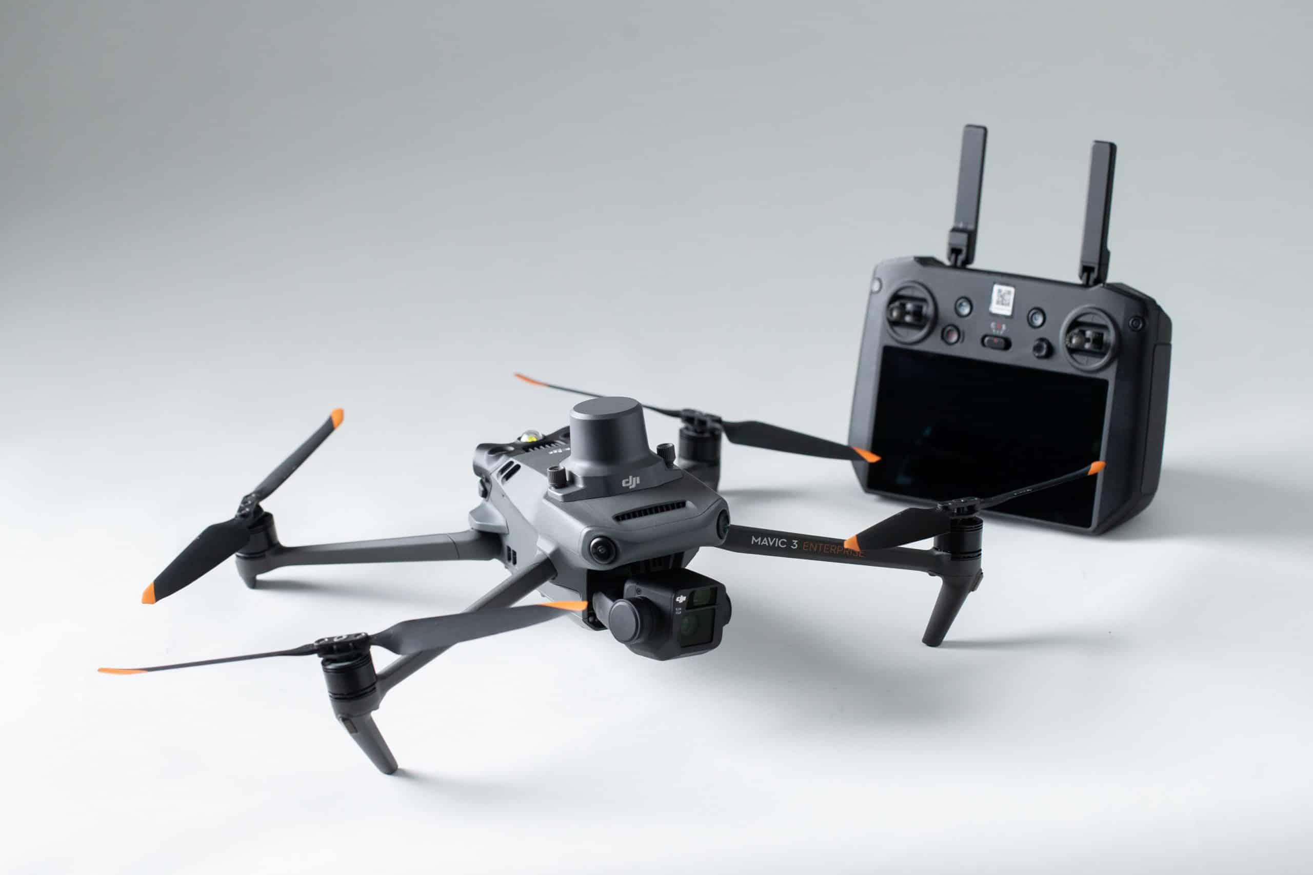
DJI Mavic 3 Enterprise
The Mavic 3 Enterprise is a commercial-grade, survey-focused UAV that’s perfect for your typical earthworks site. It’s highly suitable for precision site mapping in the civil construction, aggregates, mining, and waste management industries.
Why choose the Mavic 3 Enterprise?
- Affordability: DJI’s Mavic 3 Enterprise drone is more cost affordable than other high-accuracy options, without sacrificing any features essential for site surveying.
- Ease of use: Survey reliably, safely, and simply with a drone that’s easy to transport and operate.
- Exceptional value: The Mavic 3 Enterprise is our latest recommended drone for precision mapping. Its 30- to 40-minute flight time, light weight, increased camera pixel count, 4\20MP resolution lens, dark color for easy visibility, and 360-degree collision avoidance system make it an excellent fit for most worksites and use cases.
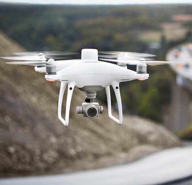
DJI Phantom 4 RTK
The Phantom 4 RTK is DJI’s first survey-focused UAV. The real-time kinematic (RTK) unit on the drone itself allows photos to be geotagged with survey-grade accuracy.
Why choose the Phantom 4 RTK?
- Affordability: DJI’s Phantom 4 RTK drone is one-third of the cost of other RTK options, without sacrificing any survey must-haves.
- User-Friendliness: Survey reliably, safely, and simply with a drone that’s easy to transport and operate.
- Best All-Around: The Phantom 4 RTK is our most recommended drone for a reason. Its 360-degree collision avoidance system, increased camera pixel count, 30-minute flight time, 20MP resolution lens, one-inch sensor, and light weight make it an excellent fit for most worksites and use cases.
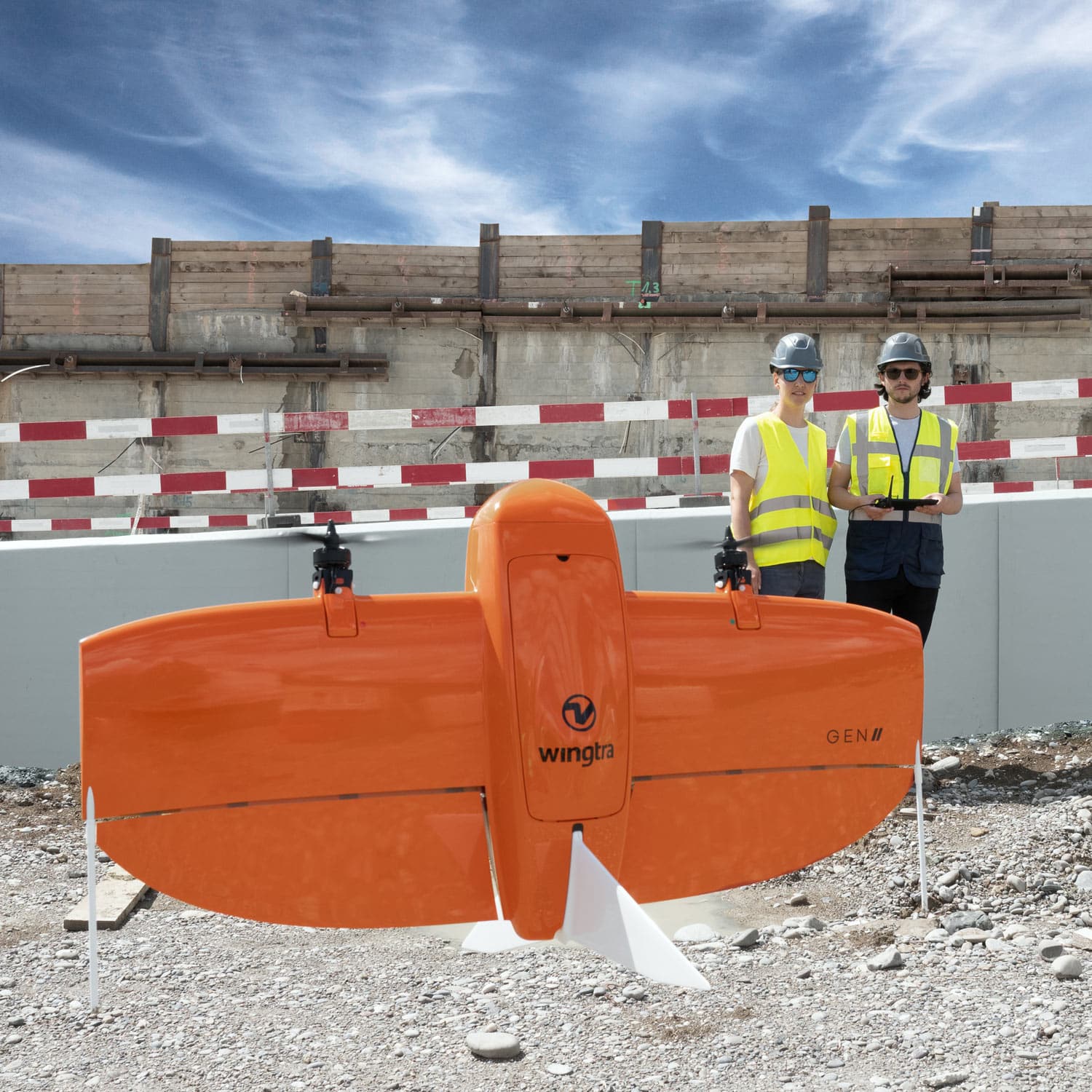
WingtraOne
The WingtraOne vertical take-off and landing (VTOL) drone allows you to conduct both small- and large-scale drone surveys with unmatched data quality—at a fraction of the time and cost.
Why choose the WingtraOne?
- Data Quality: Achieve absolute accuracy down to 1 cm (0.4 in) horizontal and 3 cm (1.2 in) vertical with the 42MP full-frame Sony RX1R II camera and the integrated PPK GNSS receiver. You can even achieve sub-centimeter level GSDs down to .7 cm under optimal operating conditions. Read more about how to achieve these results yourself.
- Efficiency: Fly at speeds up to 36 mph (16 m/s) for up to 59 minutes per flight to cover large land areas for your biggest projects.
- Coverage: WingtraOne can fly higher than drones with lower-resolution cameras, so you can cover more ground—and capture more detail—with every image.
- Take-off and land anywhere: The VTOL capability allows you to take off and land in tight spaces or rough terrain formerly accessible only to quadcopters, but with the coverage of a fixed-wing drone.
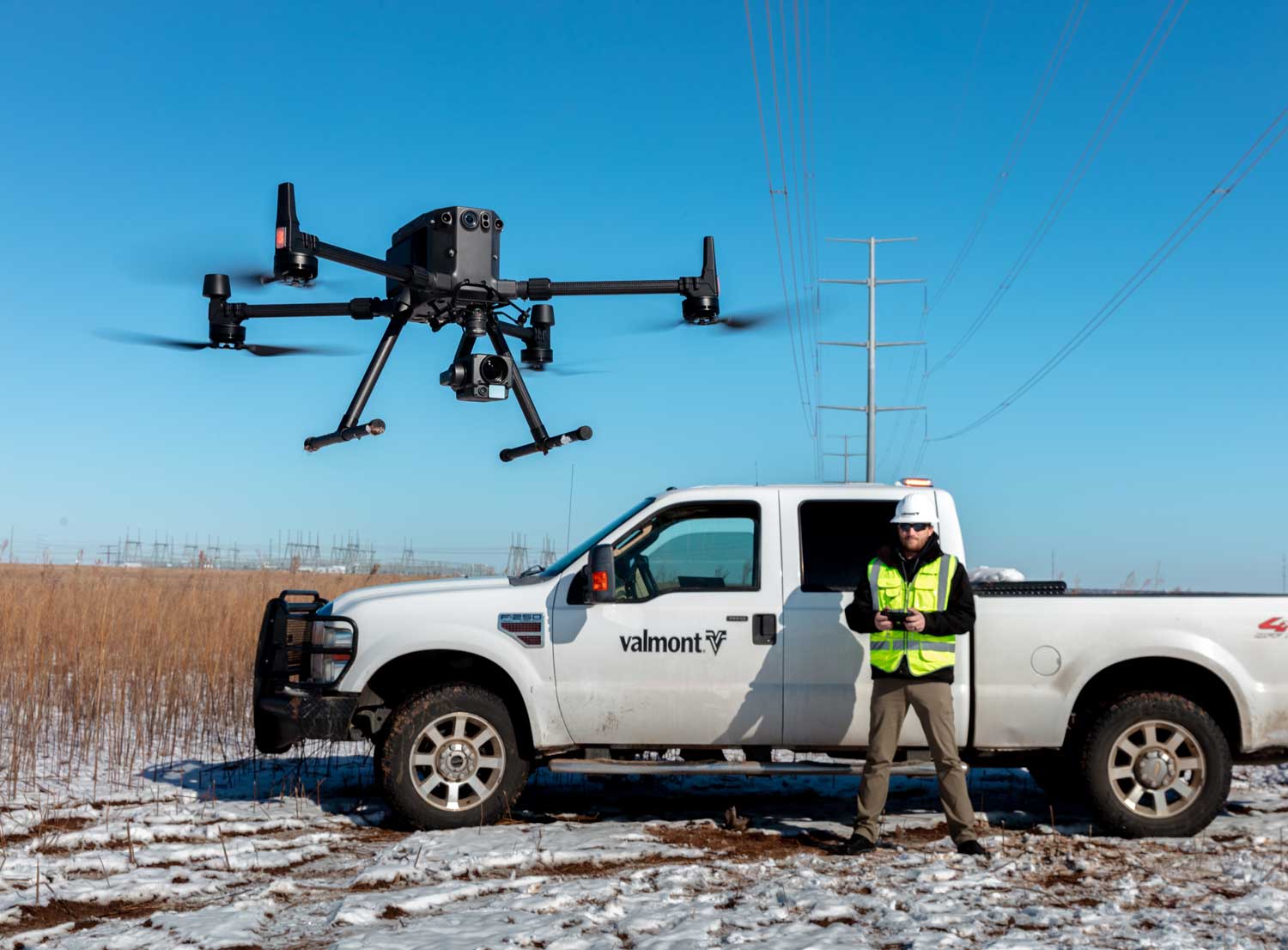
DJI Matrice 300/350 RTK
The M300/M350 drone and Zenmuse P1 sensor provide a true powerhouse experience for large-scale, complex projects or during flights in inclement weather. The real-time kinematic (RTK) unit on the drone itself allows photos to be geotagged with survey-grade accuracy.
Why choose the DJI Matrice 300?
- Site Coverage: The M300 is great for large-scale and complex worksites. It boasts an increased payload, long battery life, and advanced collision avoidance and obstacle detection sensors—which means you can fly longer and cover more ground safely.
- Speed and Performance: The M300 can handle a maximum flight time of up to 55 minutes, depending on payload, and a flight speed of 23 m/s (51.5 mph). The P1 is a compact, 45 MP, full-frame sensor camera that can take a photo every 0.7 seconds and cover 3 km2 in a single flight.
- Rugged: Ability to withstand tough conditions, the M300 can operate in -4 to 122°F (-20 to 50°C) with a self-heating battery and weather sealant that protects it from rain, dust, and even winds up to 49 ft/second.
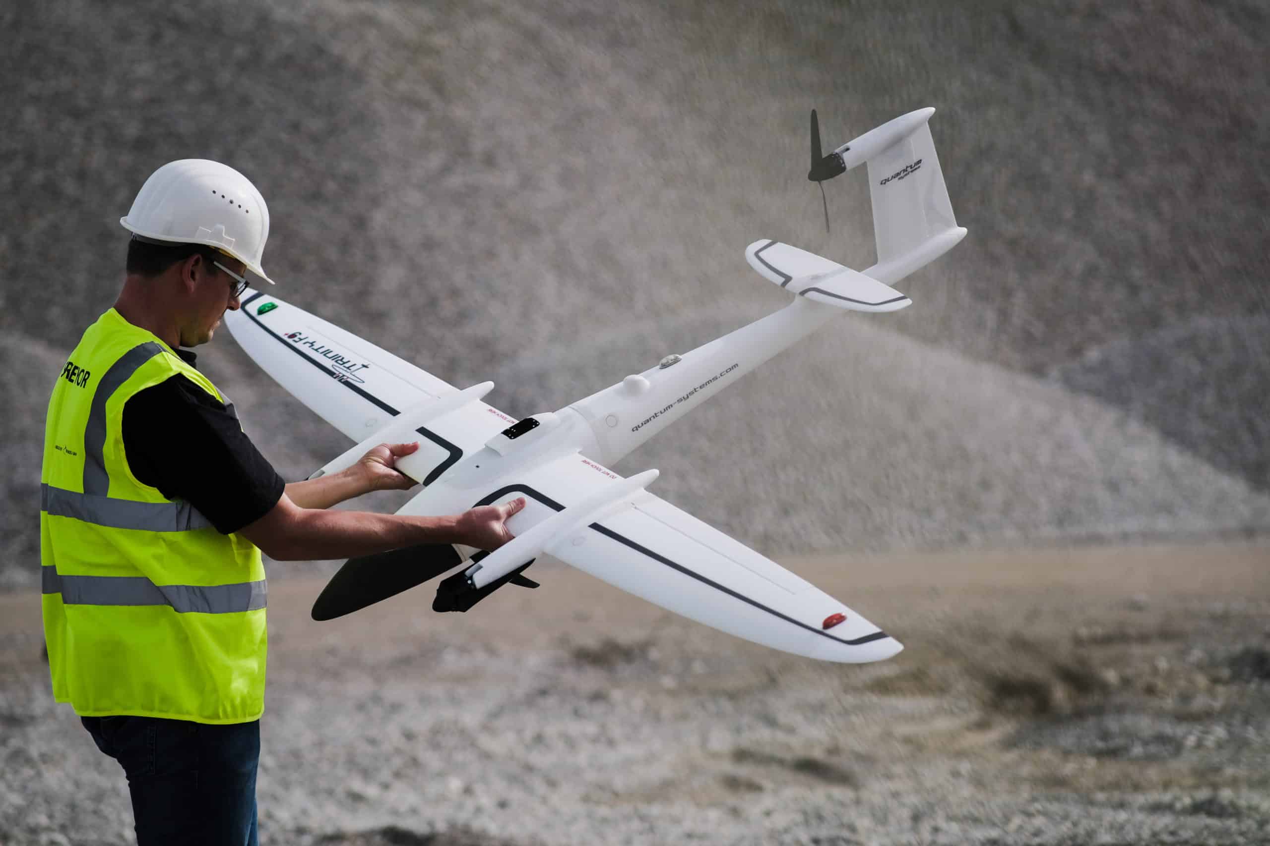
Quantum-Systems Trinity F90+
The Quantum-Systems Trinity drone is a fixed wing drone capable of flying much longer (90mins) than a quadcopter. It has the ability to takeoff and land vertically while also being able to fly longer than most other drones. The fixed wing design also helps mitigate any adverse weather like strong winds, making it a more reliable option.
Why choose the Trinity F90+?
- Up to 90 minutes of flight time – this makes it ideal for large sites due to its longer flight time when compared to other non-fixed wing drones.
- Fixed wing design – this helps mitigate any adverse weather like strong winds, making it a more reliable option. Plus it has the ability for vertical take off and landing (VTOL).
- Functionality – the Trinity F90+ leverages the VTOL UAS platform and improves many aspects to offer professional users, even more, functionality at an excellent value for money Learn more about Quantum-Systems Trinity F90+
Which drone is right for you?
Whether you already own a drone or want to explore other options, use our Supported Drones tool to find out if your perfect drone is compatible with the Propeller Platform.
Supported Drones and Camera Systems
For high-accuracy drone surveying, we recommend PPK solutions.
All of our recommended drones are PPK-enabled and manufactured by companies that have partnered with Propeller to bring a fully integrated PPK solution to life.
With the Propeller PPK workflow, these drones empower our customers to achieve 1/10ft (3cm) accuracy.
The M3E is more affordable than other high-accuracy options, without sacrificing any features essential for site surveying.
Survey reliably, safely, and simply with a drone that’s easy to transport and operate.
The Mavic 3 Enterprise’s 30- to 40-minute flight time, light weight, increased camera pixel count, dark color for easy visibility, and 360-degree collision avoidance system make it an excellent fit for most worksites and use cases.
Learn More About the Mavic 3 Enterprise
DJI’s Phantom 4 RTK drone is a third of the cost of other RTK options, without sacrificing any of the survey must-haves.
Survey reliably, safely, and simply with a drone that’s easy to transport and operate.
LEARN MORE ABOUT THE PHANTOM 4 RTK
The M300 can handle a maximum flight time of up to 55 minutes, depending on payload, and a flight speed of 23 m/s (51.5 mph). The long battery life allows you to fly longer and cover more ground safely.
With an increased payload capacity, the M300 is fully compatible with the Zenmuse P1 sensor, a compact 45 MP full-frame camera with an integrated gimbal designed for aerial surveying. It can take a photo every 0.7 seconds and cover 3 km2 in a single flight.
The M300 can withstand harsh conditions, operating in -4 to 122°F (-20 to 50°C) with a self-heating battery and weather sealant that protects it from rain, dust, and even winds up to 49 ft/second.
LEARN MORE ABOUT THE DJI M300
Collect data up to 8 times faster than multicopter drones and complete large project surveys that were previously impossible with a drone.
With its 42 MP camera and integrated PPK receiver, reach GSD down to 0.7 cm/px (0.28 in/px) and horizontal absolute accuracy of down to 1 cm (0.4 in).
LEARN MORE ABOUT THE WINGTRAONE
Up to 90 minutes of flight time makes this drone ideal for large sites due to its longer flight time when compared to other non-fixed wing drones.
Its fixed wing design helps mitigate any adverse weather like strong winds, making it a more reliable option.
remote control has a clean layout without confusing switches and levers. The Trinity F90+ and the remote controller work together seamlessly to get your job done automatically, while still providing emergency override capabilities.
Learn More About the Trinity F90+ Previous step
Frequently Asked Questions
Can you use Propeller with non-recommended drones?
Yes! The drones we recommend provide the best user experience and the most robust set of compatible features. Still, if you select a camera and drone with a strong record of high-accuracy results, we probably support it.
We don’t support drones and cameras that capture images unsuitable for surveying, as they can’t deliver the level of accuracy our customers depend on.
Why do you recommend PPK-compatible hardware over RTK solutions?
We know how important accuracy and reliability are to our customers, and Propeller PPK is the most accurate and reliable start-to-finish drone surveying and data processing solution.
An RTK drone needs to maintain a constant connection to a base station during the entire duration of a flight to collect data successfully, which means that even a slight signal loss (like flying behind a building) creates big problems.
PPK does not require this constant contact, making it a much better solution for most worksites and use cases.
However, Propeller does offer support for RTK workflows with high-accuracy geotags. Check with a sales representative or get in touch here to see if your existing hardware is compatible.
What’s the difference between recommended and supported drones?
Recommended drones have specifically been selected for optimization with Propeller PPK, and will provide the best user experience. Supported drones are compatible with the Propeller Platform, but may have limited functionality and will not support the complete PPK solution. Wondering what support is available for your drone? Check out our Supported Drones tool above, or contact us if you have questions.
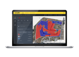
The drone you use for site surveying matters—but hardware is just one piece of the puzzle.
We’re experts at creating software that assembles your drone-collected data into a comprehensive, actionable survey.
Explore the Propeller Platform