Curious about using drones on your worksite?
Start here

Curious about drone surveying? Start here

Curious how drone surveying works? Want the broad strokes on how to get started? You’ve come to the right place.

Scroll down to learn more

Ready to Talk Dirt
and Drones?
Let’s Get Down to Business: Explore How Drone Surveying Can Make Life Easier on the Job Site
At the end of the day, you’ve got work to do. Let’s take a look at some tasks that may be on your list and how Propeller can help make them easier for you.
A better way to collect and process data
back
A better way to collect and process data
With drone surveying powered by Propeller, survey managers can easily survey more sites, more frequently. Instead of capturing hundreds of data points, you’ll capture millions with the same level of accuracy.
Populating, interpreting and sharing productivity with the team
back
Populating, interpreting and sharing productivity with the team
Using Propeller, project managers and engineers can access, track, and measure progress (cut/fill) independently, without waiting for the survey manager to fulfill their request.
Reporting Opportunities
back
Reporting Opportunities
Operational Managers can scale drone programs to streamline survey data across their organization, creating more efficient teams and proving ROI on software purchase.
Tracking quantities on daily production rates
back
Tracking quantities on daily production rates
With our add-on module, Crew, field teams have the power to spot check cut/fill elevations, earthworks progress, and design conformance from wherever you’re standing on the job—no training needed.
You’ve got work to do. We can help you do it better.

Drones & Ground Control

Just like traditional surveying requires a base and rover, drone surveying requires a drone and ground control. But what does that mean exactly? We’ve got the answers for you.

What hardware do I need?
back
What hardware do I need?
AeroPoints for ground control (which basically means you have a consistent point on the ground to help the drone software map your site), a drone (fixed-wing, quadcopter, or VTOL, depending on your needs), and a laptop or mobile device to access your data and 3D map.
What are AeroPoints?
back
What are AeroPoints?
AeroPoints™ are high-precision, smart ground control points that are easy enough for beginners, but precise enough for experts. Forget hours with bases and rovers, just lay out your AeroPoints and let them do the work.
Which drone should I use?
back
Which drone should I use?
The best drone for your worksite will depend on several factors, including budget, site size and location, team size and availability, detail requirements, and more. We recommend looking at the DJI Phantom 4, DJI Matrice 300, or WingtraOne, to start.
Do I need special training or a certification to fly a drone or use AeroPoints?
back
Do I need special training or a certification to fly a drone or use AeroPoints?
For AeroPoints, nope! With one-button operation, they are crazy easy to use. To fly a commercial drone, yes. Depending on your location, you’ll need to obtain a commercial drone pilot license. Don’t worry, though. It’s much easier than it sounds!
Check out these helpful articles on our blog for more information
Got the gist and ready to chat with someone? No problem; We got you.

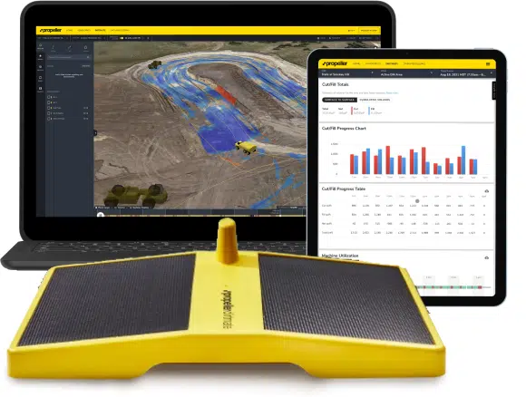
Drone Surveying Software

Transforming your drone survey from millions of images and data points to a super cool 3D map of your worksite and a reliable single source of truth for the lifecycle of your project.

Who processes the survey data?
back
Who processes the survey data?
We do. With our proprietary PPK, you just need to drag-and-drop your flight data into the software, and we’ll transform your survey into a 3D map of your worksite. We’ll also validate all data with our GIS experts, ensuring optimal quality.
How does this all fit together – drones, AeroPoints, and Propeller?
back
How does this all fit together – drones, AeroPoints, and Propeller?
Simply put, you’ll place your AeroPoints on the ground around your worksite, fly your drone, drag-and-drop your flight data into Propeller, wait 24 hours (or less), and you’ll get an accurate, interactive 3D map of your worksite.
What can I measure with the Propeller Platform?
back
What can I measure with the Propeller Platform?
Measure cut/fill quantities, surface areas, and stockpile volumes. You also can measure between previous surveys, design files, and sub grade models, as well as edit terrain to remove any inaccuracies or obstructions that cause bad data.
Is this just for our office staff?
back
Is this just for our office staff?
Nope. You can access the Propeller Platform and all your data and maps either via your laptop or even on a mobile device with Propeller’s add-on: Crew for seamless office to field (and back) communication. We don’t expect you to stay chained to a laptop to take advantage of Propeller. You’re on the move and Propeller can go on the move right along with you.
Ready to see Propeller in action? You won’t regret it.
Investing in your business should generate a return on your investment, right?
Let’s take a look at two practical examples of how you can calculate your unique ROI.
Traditional Surveying vs Drone Surveying Impact of Quantity Variance
Traditional Surveying vs Drone Surveying
To get a basic ROI, let’s assume you have ten 120-acre sites that you want to survey 5 times a year. For this example, we will say that both traditional and drone surveying cost $100 per hour.
Traditional Surveying
Traditional Survey Capacity: 5 acres per hour.
  • 120 acre site / 5 acres per hour = 24 hours
  • 24 hours x $100 per hour = $2400 per survey
If you want to survey 10 sites, 5 times a year, traditional surveying can cost you:
up to $2400 per survey x 10 sites x 5 times a year = $120,000 total yearly surveying costs
Drone Surveying
Drone Survey Capacity: 100 acres per hour
  • 120 acre site / 100 acres per hour = 1.2 hours
  • 1.2 hours x $100 per hour = $120 per survey
If you want to survey 10 sites, 5 times a year, drone surveying can cost you:
up to $120 per survey x 10 sites x 5 times a year = $6,000 total yearly surveying costs
That’s annual net savings of $114,000!
Impact of Quantity
Variances

Cost per cubic yard moved is very unique to your business. For this exercise, we’ll take an average number of $5.00 per cubic yard moved.

On average you can see a 5% quantity variance in quantities moved with traditional surveying methods. Drone surveys, however, are more dense, which means they are capable of identifying more quantity through a number of data points, thereby lowering the variance.

Now, let’s take a look at the cost associated with a 5% variance with traditional surveying, compared with a 3% or 1% variance when using drone surveying.

5% Quantity Variance
Common average with traditional surveying
$5.00 per cubic yard moved x 250,000 average quantity moved per year x 5% quantity variance = $62,500 cost associated with variance
3% Quantity Variance
with drone surveying
$5.00 per cubic yard moved x 250,000 average quantity moved per year x 3% quantity variance = $37,500 cost associated with variance.
1% Quantity Variance
with drone surveying
$5.00 per cubic yard moved x 250,000 average quantity moved per year x 1% quantity variance = $12,500 cost associated with variance.
Using this calculation, shifting from traditional surveying to drone surveying could net your business a savings of $25,00 – 50,000.
Ready to invest in the future of your business?
How Are People Using Drone Surveying in Your Industry?
Civil Construction
Bidding & Pre-Construction
  • Capture the initial state of a project before breaking ground
  • Reduce downtime
  • Improve scheduling
  • Gain a competitive edge in the selection process
Progress Tracking
  • Capture changes as they happen
  • See what’s been done and what’s left to do
  • Identify and address issues
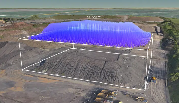
  • Perform quick volume calculations of material moved
Access Site Data and 3D Maps, Any Time, Any Where
  • Interactive 3D maps
  • Unlimited users using a single source of truth for your worksite
  • Generate PDF or CSV files
  • Add-on Crew for simple office to field communication (and back)
Customer Spotlight: Jonathan Wills, Wills Bros

“Prior to Propeller, we were acting on information that was already weeks out of date. Now, we’re ahead of the curve and can make decisions based on actual facts, not assumptions.”

Mining
Full Project Lifecycle Documentation
  • Capture changes as they occur
  • Inspect and measure pit angles
  • Track earth movement
  • See what’s been done and what’s left to do
Simple Inventory Management
  • Calculate stockpile volumes
  • Translate stockpile volumes to $$
  • Instantly share reports
  • Easy end-of-month reconciliation and financial forecasting
Access Site Data and 3D Maps, Any Time, Any Where
  • Interactive 3D maps
  • Unlimited users using a single source of truth for your worksite
  • Generate PDF or CSV files
  • Add-on Crew for simple office to field communication (and back)
Customer Spotlight: Ben McKnight, Nevada Gold Mines

“We proved within those first couple months the value of the data we were getting out of the stockpiles. It didn’t even make sense to anybody that you could get this much data, this quickly, with this much accuracy.”

Aggregates
Safe, Accurate Site Surveys
  • Verifiable accuracy to 1/10 ft
  • Improve worker safety
  • Generate 3D and 2D maps of quarry
  • Survey more ground in a fraction of the time
Full Project Lifecycle Documentation
  • Capture changes as they occur
  • Inspect and measure pit angles
  • Track earth movement
  • See what’s been done and what’s left to do
Simple Inventory Management
  • Calculate stockpile volumes
  • Translate stockpile volumes to $$
  • Instantly share reports
  • Easy end-of-month reconciliation and financial forecasting
Customer Spotlight: Jonas Thim, Peab

“We have streamlined the measurement process for stockpiles. Before, the calculations were made in another software. This process was both costly and time consuming. We now scan several times a year and measure directly in Propeller.”

Waste Management
Safe, Accurate Site Surveys
  • Verifiable accuracy to 1/10 ft
  • Improve worker safety
  • Generate 3D and 2D maps of quarry
  • Survey more ground in a fraction of the time
Accurate Density & Volume Calculations
  • Get accurate calculations of compaction densities
  • Monitor remaining airspace
  • Detect liner breaches
  • Detect liner breaches
Access Site Data and 3D Maps, Any Time, Any Where
  • Interactive 3D maps
  • Unlimited users using a single source of truth for your worksite
  • Generate PDF or CSV files
  • Add-on Crew for simple office to field communication (and back)
Customer Spotlight: Trent Girouard, Santa Maria Landfill

“If we needed to know right now how much airspace we have left, it’d be no problem for me to go outside, fire up the drone, fly it really quickly, and have the answer back in less than a day.”

Can you see drone surveying in your team’s future?

Drone surveying is no longer a “futuristic” idea for earthworks. It has risen sharply in popularity over the last several years in a wide range of earthworks businesses, large and small.

At Propeller, we believe that everyone should have reliable, easy access to accurate site information, complete with interactive 3D maps. What once may have seemed out of reach, is now fully accessible—anytime, anywhere.

You’ve made it this far, what have you got to lose by checking out a demo and seeing if drone surveying with Propeller fits your business and your team? (hint: nothing)

Let’s Get Started with a Demo
Ready to Talk Dirt
and Drones