


How is Drone Surveying More Efficient for Stockpile Management & Volume Calculations?
For mining professionals, stockpile inventory management and stockpile volume calculations are two of the primary use cases for drone surveying. The 3D maps generated from drone flights include actionable data such as stockpile volume calculations that can show changes over time and easily share visualized reports with team members across multiple locations.
By flying a drone to measure stockpile volumes instead of sending workers out to traverse a dangerous site, project managers can track their inventories and site progress in a faster, safer, and more reliable way.
Mine and quarry managers spend much of their time answering questions—or trying to answer questions—about quantities:
- How much is sitting in the stockyard right now?
- How much is going in the crusher or mill?
- What still needs to be extracted?
When you have accurate site surveys at your fingertips—and thus full oversight of your stockpile inventory—finding the answers you need becomes simpler. Drone surveying workflows, with a solution like the Propeller Platform, provide dependable, highly accurate stockpile measurements. And you can measure progress as frequently as you want to fly. This readily available stockpile inventory data enables teams to optimize worksite operations, which include financial forecasting, supply-chain management, and accurate reconciliation.
However, before making a stockpile volume measurement, you need to capture site data with a drone flight. “Drone surveying” basically means using a drone to take aerial photos of your site, combined with some form of GPS data and ground control to provide geographical coordinates.
Flying a drone to survey your site is significantly faster—up to 10x faster, by some estimates—than traditional ground-based methods. It’s also safer for a drone pilot to stand by and let the drone collect the data instead of walking the potentially dangerous mine site.
Once you’ve captured your imagery and ground control data, it needs to be processed into a 3D model. Propeller processes drone data with a 24-hour turnaround, so you can devote your time to other duties. You get easy access to data outputs: point clouds, digital elevation models, and more. These can be exported for use in other GIS and CAD programs.
A good way to think of drone data analytics is how it improves run of mine (ROM) volumes. The ease of surveying with an unmanned aerial vehicle (UAV) allows for more frequent surveys. Quickly calculating accurate volumes with the Propeller Platform increases ROM management with more consistent grades throughout the mill and overall increased accuracy and safety.
Ensuring you have the correct grade blends processed through your mill is essential to success. Too often, insufficient input grades are only discovered after the fact, when the final resource doesn’t connect with the material with which you began. It’s nearly impossible to send someone out to walk those stockpiles, but with drone surveying you can capture the data you need in hours, not days. Once your survey is rendered in Propeller, you can begin measuring stockpile volumes with an easy-to-understand colorized slope map. To get a better idea of overall progress, just upload your design surface and compare with the 3D survey, right in your browser. You can also use drone-captured data for elevation surveys of blast areas. Whether you’re flying your whole site regularly or are specifically targeting areas for pre-blast planning or ROM management, you can use the 3D survey to accurately calculate levels in just a few clicks. And, if you have any design or linework, overlay that into the model to help with accuracy and quality.
For ROM volumes, the ease of surveying with a drone and calculating volumes with the Propeller Platform allows for more frequent flights, which means better ROM management and more consistent grades throughout the mill. Fly weekly or daily instead of the traditional monthly surveys. Regular drone surveys mean you have frequent data on your mine. This means that you can keep an eye on the work being done on your ROM pad as often as you fly. Ensure that everyone is pulling from the right stockpiles to make the right grades for your mill with a processing platform like Propeller.
What Benefits Do Drones Offer for Mining and Aggregate Companies?
The benefits that drone surveying offers are enormously varied in their applications. But across different industries whether in construction, mining, or waste management the benefits can be grouped into 4 major categories.
- Efficiency
- Cost Effectiveness
- Increased Data Accuracy
- Improved Safety Standards
Efficiency – The first and most important benefit that drone surveying offers mining companies is a wildly more efficient surveying process that severely cuts down on the time and financial resources needed to survey a site. Any company that has been through the process of surveying a site knows that it is not an easy task. It requires a lot of time, a workforce with a very particular skill set, and a significant time commitment that can increase if anything goes wrong. When it comes to the mining industry drone surveying will most often be used to measure and record stockpile volumes. These stockpiles represent enormously important assets for these companies, and they often go through daily changes that means frequent surveying to ensure the most up to date data is being collected. These stockpiles often represent significant assets that are required parts of completing a project on time, and in other situations they can be important financial assets which can have significant impacts on taxes, for instance. So making sure that this data is as accurate and up to date as possible is very important for mining companies. With traditional surveying methods about five acres can be surveyed per hour. In comparison an experienced drone surveyor could survey 100 acres in a single hour. When the increased efficiency of drone surveying is taken into account it not only gets jobs done much more quickly but with the number of hours that surveyors need to work the total necessary financial investments is also significantly reduced. The graph below shows in more detail just how much time and money can be saved by switching to drone surveying from traditional surveying methods.
Cost Effectiveness – As was mentioned above the efficiency of drone surveying not only helps to shorten timelines but it also helps to significantly reduce expenses related to surveying fees. When using traditional surveying methods the collection of the data requires a much longer and more drawn out process. With that process comes workers who have salaries, expensive equipment, and a ton of other costs that tend to appear out of the chaos of any mining site.
The slower process of traditional site and stockpile surveying compounds on itself the more a site or stockpile has to be surveyed. With the way that mining companies have to repetitively measure the volume of stockpiles the slowness and costliness only begins to pile up along with all the other delays that can occur when things go wrong as they often do on hectic work sites. All in all the increased efficiency of drone surveying also leads to increased project efficiency that can deliver more accurate and timely data on daily and weekly basis to help ensure that projects come in on time and on budget.
Increased Data Accuracy – The process of how data is collected through drone surveying is different from how traditional surveyors gather data. Drones use a technology called photogrammetry that stitches together hundreds and sometimes thousands of overlapping photos that take into account different angles and perspectives to measure data from within the areas surveyed. Along with other technologies like RTK GPS technology, drone surveying is able to provide a level of efficiency and accuracy that is nearly impossible to match with traditional surveying methods.
For people who are new to drone surveying technology it’s understandable that a lot of this may seem confusing at first. This is where one of the most important variables to a successful drone surveying program comes into play. If you work with a drone surveying company or software service provider that does not provide a robust support team and resources to help educate you and your team on the intricacies of drone surveying and provide live support to walk you through any problems its very easy to end up with an expensive headache that does not provide much utility. Luckily Propeller has a wealth of resources to help educate our customers along with a customer success engineering team that is solely dedicated to helping Propeller customers. This is a team of experts on drone surveying that knows how to properly implement a drone surveying program.These resources contribute enormously to the increased accuracy of a drone surveying program. The innovative technologies offered by drone surveying are what has disrupted the surveying industry but without the proper resources, education, and live guidance, it is very easy for mistakes to be made with a drone surveying program that will end up with the user not receiving the full benefits that drone surveying offers.
Improved Safety Standards – While surveying is considered an essential part of the mining industry. It can often be seen as a small side project to the overall project. Surveying teams are contracted out from external contractors who show up, do their job, and leave while the rest of the project proceeds. While it is true that surveying is just one part of a much larger project, the dangers present on mining sites can affect the whole project, and monitoring those with a drone surveying program makes the entire operation safer.
When it comes to surveying, surveyors are often required to get themselves into difficult to reach locations that can easily put them into harm’s way. With all the moving pieces and the chaos on a mining site that comes from things like heavy machinery, blasting, and other hazards it’s very easy for a confused surveyor to end up in a potentially dangerous situation. With digitally enabled drone surveying, surveyors are capable of gathering all of the information that they need without having to physically position themselves in the middle of everything. Also, Propeller offers site maps and data gathered through surveying in easily accessible digital file formats that allow site data to be analyzed and shared from back office locations. This info can also easily be shared with sub-contractors working across multiple teams that are not always perfectly coordinated. With this increased communication and collaboration, mistakes on the job site are much less common and team safety performance will naturally increase.
Fill in the form to get your demo:
How is Drone surveying more efficient for stockpile Management & Calculations?
For mining professionals, stockpile inventory management and stockpile volume calculations are two of the primary use cases for drone surveying. The 3D maps generated from drone flights include actionable data such as stockpile volume calculations that can show changes over time and easily share visualized reports with team members across multiple locations.
By flying a drone to measure stockpile volumes instead of sending workers out to traverse a dangerous site, project managers can track their inventories and site progress in a faster, safer, and more reliable way.
Mine and quarry managers spend much of their time answering questions—or trying to answer questions—about quantities:
- How much is sitting in the stockyard right now?
- How much is going in the crusher or mill?
- What still needs to be extracted?
When you have accurate site surveys at your fingertips—and thus full oversight of your stockpile inventory—finding the answers you need becomes simpler. Drone surveying workflows, with a solution like the Propeller Platform, provide dependable, highly accurate stockpile measurements. And you can measure progress as frequently as you want to fly. This readily available stockpile inventory data enables teams to optimize worksite operations, which include financial forecasting, supply-chain management, and accurate reconciliation.
However, before making a stockpile volume measurement, you need to capture site data with a drone flight. “Drone surveying” basically means using a drone to take aerial photos of your site, combined with some form of GPS data and ground control to provide geographical coordinates.
Flying a drone to survey your site is significantly faster—up to 10x faster, by some estimates—than traditional ground-based methods. It’s also safer for a drone pilot to stand by and let the drone collect the data instead of walking the potentially dangerous mine site.
Once you’ve captured your imagery and ground control data, it needs to be processed into a 3D model. Propeller processes drone data with a 24-hour turnaround, so you can devote your time to other duties. You get easy access to data outputs: point clouds, digital elevation models, and more. These can be exported for use in other GIS and CAD programs.
A good way to think of drone data analytics is how it improves run of mine (ROM) volumes. The ease of surveying with an unmanned aerial vehicle (UAV) allows for more frequent surveys. Quickly calculating accurate volumes with the Propeller Platform increases ROM management with more consistent grades throughout the mill and overall increased accuracy and safety.
Ensuring you have the correct grade blends processed through your mill is essential to success. Too often, insufficient input grades are only discovered after the fact, when the final resource doesn’t connect with the material with which you began. It’s nearly impossible to send someone out to walk those stockpiles, but with drone surveying you can capture the data you need in hours, not days. Once your survey is rendered in Propeller, you can begin measuring stockpile volumes with an easy-to-understand colorized slope map. To get a better idea of overall progress, just upload your design surface and compare with the 3D survey, right in your browser. You can also use drone-captured data for elevation surveys of blast areas. Whether you’re flying your whole site regularly or are specifically targeting areas for pre-blast planning or ROM management, you can use the 3D survey to accurately calculate levels in just a few clicks. And, if you have any design or linework, overlay that into the model to help with accuracy and quality.
For ROM volumes, the ease of surveying with a drone and calculating volumes with the Propeller Platform allows for more frequent flights, which means better ROM management and more consistent grades throughout the mill. Fly weekly or daily instead of the traditional monthly surveys. Regular drone surveys mean you have frequent data on your mine. This means that you can keep an eye on the work being done on your ROM pad as often as you fly. Ensure that everyone is pulling from the right stockpiles to make the right grades for your mill with a processing platform like Propeller.
How are Drones Improving Safety in Mining & Aggregates?
There are many variations of passages of Lorem Ipsum available, but the majority have suffered alteration in some form, by injected humour, or randomised words which don’t look even slightly believable. If you are going to use a passage of Lorem Ipsum, you need to be sure there isn’t anything embarrassing hidden in the middle of text. All the Lorem Ipsum generators on the Internet tend to repeat predefined chunks as necessary, making this the first true generator on the Internet. It uses a dictionary of over 200 Latin words, combined with a handful of model sentence structures, to generate Lorem Ipsum which looks reasonable. The generated Lorem Ipsum is therefore always free from repetition, injected humour, or non-characteristic words etc.
How Are Drones Used in Mining Exploration?
The first priority on any mine is safety. From everyday safety plans to inspections to traffic management, safety is in everything you do. However, these things take time and resources to get right, and they are mandatory. Using a drone surveying solution like Propeller allows you to reduce the time spent completing these tasks,. Because the surveys are accurate and up-to-date, the need for in-person inspections is decreased, or sometimes eliminated. You can quickly measure haul roads to ensure they meet safety standards for both grades and windrow heights. I
For example, you could provide the inspector with view-only access to your survey data, and they could visually inspect your site from miles away on any browser-enabled device. These images you can obtain from drone surveying are high-resolution and shareable. Fixed plant and pit face inspections can be done in a few clicks of your mouse. Slip management takes a fraction of the time. Short- and long-term traffic management can be streamlined with accurate visuals of assets, past vehicle movement, and existing roads. Both the orthophoto of the mine and individual images are accessible and downloadable from the Propeller Platform. You can use them to map out the current day’s route with your team or more safely track stockpile volume changes .
How Have Drones Changed the Mining Industry?
Mines and quarries are highly exposed to market price fluctuations and the changing tides of consumer demand. New tools that can increase productivity, improve safety standards, and reduce operational costs are of particular importance. Recent advances in commercial drone technology and drone mapping analytics platforms have changed the landscape of the mining and aggregates industry for good.
Surveying is an essential task in mining, but traditional methods were time-consuming, expensive, and infrequent. This was a pain point for mining businesses because accurate, up-to-date data is key to effective progress and productivity tracking, stockpile volume management, and design conformity.
Fortunately, drones have become an affordable and accessible tool for mine operators, making them more common on modern mining sites than a GPS rover (though just as vital). Unlike traditional survey tools like a base and rover, drones don’t require hours of specialized training and education to operate. Drone surveying programs are quick and easy to deploy, yielding unparalleled access to fast, precise data.
Here are just a few of the ways drone technology has already transformed the mining industry.
Stockpile management and reporting
Thanks to modern, easy-to-use drone technology, the days of surveyors walking a stockpile to take measurements and calculate stock volumes are over. Using a drone, any trained site worker can now capture the entire sales yard very quickly and view the processed dataset within a day. Accurate volume calculations and comparisons can be generated in seconds within Propeller’s cloud platform, with all measurements easily exported to CSV files.
The end-to-end process is so simple that site teams can record stockpile volume data much more frequently, improving ROM management and ensuring more consistent grades throughout the mill. Ben McKnight of Nevada Gold Mines detected a 30% discrepancy in stockpile reporting within a month of flying his first drone.
Rapid data collection has led directly to increased productivity and better decision-making thanks in large part to accurate stockpile volume calculations.
Planning and building
Drone-collected data yields an accurate visualization of worksites, enabling improved pit and dump design and management. Regular short flights yield a visual record of changes over time, allowing site managers to check weekly or monthly pit volumes and compare the current surface against previous datasets.
Teams can overlay KLM design files on orthomosaic 3D models to check the conformance of the site surface and determine exactly how much material should be extracted to match the design. Modeling sediment flow on drone-captured elevation maps also allows for better planning of tailings basin operations and tailings dam maintenance, helping to maintain structural integrity and avoid failures.
Drilling and blasting
Because planning and executing blasting work in an open pit mine or quarry requires accurate, timely data, drone surveys have proven to be an effective solution. Any blast area can be easily and inexpensively surveyed by drone. Platforms like Propeller convert raw data into 3D site models, allowing easy drill depth calculations and analysis.
Pre-blast drone surveys are also indispensable sources of data, including rock type variation in a bench, face angle, pre-blast block condition, and pre-blast volumes. Post-blast drone surveys provide data for measuring post-blast volume and a visual assessment of blast results, including muck pile shape, back damage, and distribution and fragmentation.
Haul road monitoring
Drone data makes regular assessment of haul road conditions and accurate traffic planning a simple task. Teams can calculate haul road lengths, measure windrow heights, check slopes and grades, monitor switchbacks, and check roads against design and safety requirements in just a few clicks, keeping sites running smoothly and safely.
Inspections
Inspecting hard-to-reach areas has long been a pain point in mining—one that drones have all but eliminated. Drones can quickly and inexpensively survey areas that are tricky to access, yielding high-resolution images showing detail that is not visible from the ground.
Environmental departments can ensure that site boundaries are maintained and protected areas are not disturbed. Geologists can perform accurate geotech mapping and rock face inspections, assisting in the close monitoring of fixed plants. 3D maps are also used to inspect and measure pit angles, calculate blast volumes, and overall keep projects running on schedule and on budget.
Worksite safety
Safety is paramount in mining and aggregates, and drones are helping improve the safety of this dangerous occupation every day. Drones can survey dangerous and unstable terrain, reducing risks to personnel by keeping them away from potentially hazardous areas like the bottom of the pit, block caves, and heavy traffic areas.
Regular drone surveys also help teams better anticipate and detect worksite hazards, improving overall site safety. Teams can easily check windrow heights, berms and tailings dams, measure overall pit slope, and assess individual slope angles to maintain compliance with safety requirements.
Using Propeller’s timeline feature to compare datasets and track changes over time, site managers can monitor movement of highwalls and identify potential slips or rock falls before they happen.
Reclamation and other environmental objectives
Reclamation is intended to minimize the adverse impact of mining on the surrounding ecosystem. In recent years, the focus on land reclamation efforts and other environmental objectives has increased significantly. The most common steps after a mine has reached the end of its lifespan are reforestation and new development, work that is planned long before blasting begins on a site.
Historically, it was difficult to track progress toward reclamation efforts and to predict maturity dates, but drones have streamlined every step of the process. Mine operators can design better blasting plans, firm up timelines, evaluate lifespan, and keep all stakeholders informed using drone surveying platforms like Propeller.
Site managers have also found several ESG benefits in adopting a drone surveying workflow:
- Environmental: Non-intrusive site inspections, water management monitoring and erosion control, remediation documentation, and improved traffic flow to reduce fuel burn.
- Social: Blast wall and terracing inspections for improved worksite safety, combating the labor shortage by offering the opportunity to work with cutting-edge tech.
- Governance: Compliance with local regulations, improved investor confidence, and easy-to-share documentation and record-keeping.
Used correctly, drones enable faster, more affordable, and higher-resolution surveying without sacrificing accuracy. A successful drone program provides mining businesses with accurate, up-to-date information on onsite progress and productivity so firms can increase quality while minimizing operational risk and reducing spend.
How drone surveying for mining can help protect the environment.
Environmental regulations are a regular part of mining, whether it’s checking runoff after a large rainfall or waste dump conformance. During mining operations, you need to keep tabs on the site boundaries and “no-go” zones to avoid any fines associated with failed inspections or violations. In addition to the benefits delivered with more frequent drone surveys and a visual 3D interface on a platform like Propeller, you can also mark off protected areas on your mine site. This keeps the entire work team on the same page and shows exactly where they need to be cautious. But the largest and most costly environmental protection job comes during rehabilitation. Once the mining operations conclude and rehabilitation begins, you need to be sure the mine site conforms to design or risk fines for breaking EPA regulations. Drone surveying can help.
Environmental hazards also factor into the mining process. From erosion to soil, groundwater, and surface water contamination, irresponsible mining can cause catastrophic, long-term damage. Worldwide, codes and regulations are used to help minimize a mine’s impact on the environment and human health. Furthermore, new environmental, social, and governance (ESG) concerns are challenging mining companies to operate as responsibly as possible in every aspect of business.
Surveying with drones on mining sites provides a remarkable opportunity for teams to address these ESG concerns. Since a typical mine is located away from built-up areas, it’s generally easy for surveyors to make flight plans in accordance with aviation regulations. Here are a few other benefits drone surveying can provide your mining operations:
- Drones make non-intrusive site inspections, providing quick analysis of earthworks, stockpile volumes, surface cracks, and positioning of equipment with virtually no environmental impact.
- Data collected on a regular basis via drone can protect nearby vegetation, landmarks, and waterways.
- During construction of new mines, drone surveys document all equipment on-site and all site hazards, which provides a safer environment for workers.
- During regular operations at the mine, teams have up-to-date information to monitor water management and keep erosion under control.
- When closing a mine, drone surveys can monitor and document the remediation process to insure EPA compliance.
What A Mining Company Needs to Start Drone Surveying
Implementing a drone surveying program on your worksite is more straightforward than it may sound. There are only three key pillars that need your attention:
- Training and certification
- Drone hardware and ground control
- Mapping software
Read on to explore each of these pillars in detail.
Training and certification
Drones are regulated differently depending on the country and region where your worksites are located. You must pay attention to and follow the flight regulations in your area or risk fines and possible legal consequences.
As a first step, look into the airspace above your site and find out whether there are any restrictions or special licensing requirements. We’ll discuss some common locations below, but if yours isn’t on the list, you can use the Global Drone Regulations Database to check regulations for your country. You can also use apps such as the B4YouFly app for the U.S. to check regulations based on your specific location.
In general, unmanned aerial vehicles (UAVs) are monitored by the country’s aviation regulator, so check out the aviation authority for your country if you can’t find information elsewhere.
United States
U.S. commercial drone regulations are managed by the FAA, which requires a Part 107 Remote Pilot Certificate to fly. Critical aspects of drone operation include keeping drones within visual line of sight, flying below certain altitudes, and maintaining specific safety standards when flying over people. Getting your Part 107 license requires some coursework and an exam, but the process is easier than you think. The test consists of multiple-choice questions covering key aviation terms, weather considerations, and regulations pilots must know. Most of these answers are intuitive.
Canada
You need a special flight operations certificate (SFOC) to fly commercially if your drone weighs over 25 kg. Under 25 kg, you may qualify for special exemptions; check the civil aviation site to learn more.
Australia
Thanks to recent changes in legislation, anyone can fly a drone under 4.5 lb (2 kg) without a license, but you’ll still need to register for an ARN before flying commercially. You can register here. If you’ll be flying a drone larger than 2 kg, pilots must have a Remote Pilot License (RePL), which involves taking an official course and assessment.
Europe
The European Union Aviation Safety Agency (EASA) recently replaced each member country’s existing laws relating to drone operation with a unified set of standards, making it easier to operate drones across the 28 EU member states plus Iceland, Switzerland, Liechtenstein, and Norway.
For more detail on region-specific requirements, read our overview of commercial drone regulations in the U.S., Australia, and Europe.
Best Drones For Mining Companies
The best drone hardware for your mine depends on a number of factors, including size, budget, and image resolution requirements.
Size
If your mine is 200 hectares (500 acres) or less, it can be surveyed comfortably with a multicopter. Larger sites will probably need either more than one multicopter or a fixed-wing/ VTOL drone.
Budget
Multicopters like those made by DJI are mass-produced and can be easily and inexpensively purchased. Fixed-wing and VTOL UAVs are still made in limited quantities, making the units more expensive than their multicopter counterparts. Along with the initial sticker price, remember to factor in the added cost of maintenance and the availability of parts.
Camera
A good camera for surveying should have a 20MP sensor or better. Avoid interchangeable lenses unless you’re certain you’ll need them, and look for a larger sensor and a 35mm-equivalent focal length. These specifications will enable you to get as much detail as you need about any point and increase your image contrast for better 3D renderings and point clouds. For more detail on what camera is best for drone surveying, check out this article.
At Propeller, we’ve partnered with quality drone manufacturers to bring you a range of options that complement our platform and workflows, including but not limited to:
- DJI Mavic 3 Enterprise
- DJI Phantom 4 RTK
- DJI Matrice 300 RTK
- WingtraOne VTOL GEN I and GEN II
- Quantum-Systems Trinity F90+
For a complete list of recommended and compatible drones, use our online guide.
Finally, if you’re worried about operating your drone—don’t be! Apps make the process of flying a breeze. Setting up your drone’s flight path takes only a few minutes. Once that’s done, simply hit go and monitor from there with no manual control involved. Watch our First Flight video to learn about registering your drone, what to do in the office before your flight, what to do on-site, and how to conduct your first flight.
Ground control
You can use manual ground control points (GCPs) in a drone surveying workflow or add smart ground control like Propeller’s AeroPoints for a seamless, end-to-end surveying solution.
AeroPoints take all the manual effort out of ground control, providing a critical on-the-ground reference point for high-accuracy data capture without the hassle of manually marking and moving points as work progresses.
With Propeller PPK, you only need one AeroPoint device to serve as a combination GCP and base station on most worksites up to 100 acres.
You can complete a drone survey using AeroPoints as your ground control in just a few simple, efficient steps:
- Place your AeroPoint on the ground nearby and turn it on
- Initiate your pre-programmed drone flight, and fly your site for at least 10 minutes.
- Connect to a wifi network to upload your aerial survey data
Bluetooth and wifi-enabled technology allow AeroPoints to communicate directly with your drone hardware and mapping software, so all the legwork is done for you in the cloud. To learn more about AeroPoints, check out this post.
Mapping software
Last, but certainly not least, you’ll want to pick the right software for your mining site. Software, unlike hardware, is not an interchangeable tool. As mining superintendents know all too well, mining operations are complex, involving many layers of oversight, design, and management. It’s critical to pick the software that best supports your workflows.
Flight planning apps
The importance of a steady, consistent flight when surveying cannot be overstated. The best way to achieve reliable flight quality is with a flight planning app like DJI’s Ground Station Pro. We’ve field-tested this app ourselves, conducting 3D aerial surveys, precision mapping, and drone inspection flights. With only minor adjustments (like setting the front and side overlap to 75% and setting the aspect ratio to the highest resolution available), we achieved high-quality maps that yielded survey-grade data.
Processing, measurement, and visualization software
As the final step in the process, the raw drone imagery and data must be stitched together, matched to ground control positions, and processed by powerful software with data experts at the helm. Processing photogrammetry data is a resource-intensive and technical process—and thanks to cutting-edge platforms like Propeller, your team can avoid all that work!
Cloud-based programs like Propeller are an efficient and cost-effective way to leverage powerful computing that scales with your business and requires no installation, maintenance, or expertise from your team. Device-independent software also makes collaboration and sharing amongst stakeholders significantly easier.
Propeller’s advanced mapping and analytics software assembles thousands of drone images into a three-dimensional map of your site. This map isn’t just visual; it’s rich in data, including elevations, distances, and GPS coordinates. The Propeller Platform allows users to track the progress of any project over time, calculate stockpile volumes, check road grades, monitor environmental zones over time, and so much more.
How Are Drones Used in Mining Exploration?
When it comes to exploration for mining companies the areas that need to be explored are often hazardous and very difficult to navigate. It’s not uncommon for valuable mineral deposits to be tucked away in dangerous and difficult to reach areas. Mountain ranges, deserts, and ravines are common areas for mining exploration teams to find themselves in. With the addition of drones, navigating these locations becomes much easier and safer than it was before. Every different surveying method has its own advantages and disadvantages. With drone surveying the largest benefit is that enormous areas can be surveyed in a quick, safe, and cost efficient manner. In addition to this, when drone surveying is mixed with a software like Propeller it can produce high quality photos and 3D models that show site progress, volumetric tracking, and can help to identify potential areas that are potential mining sites. In comparison to ground surveying methods drone surveying can gather a sum of data in a single flight that could take a full surveying crew 2 weeks to gather.
Despite their slower speeds, land based surveying methods do have some advantages for mining exploration. The main benefit is that ground based surveying methods are capable of gathering soil and rock samples that can be tested for the presence of certain minerals, precious metals, natural resources, or other materials that could be mined. Of course at this point soil and rock samples can also be gathered by hand often in much larger quantities. As well, base and rover surveying often requires a flat surface to operate effectively so for exploration of untapped mining sites the rugged terrain often gets in the way.
What’s the difference between a mine drone and a regular drone?
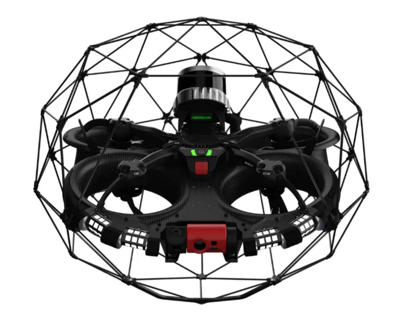
The difference between a mine drone and a regular drone is simple, mine drones are designed to be used in enclosed spaces rather than large open spaces. This often involves drones being reinforced in one way or another to be more durable to bumping into things in cramped, enclosed environments like a mine. Flyability’s Elios 3 drone pictured below is a great example of a drone design better suited for mining exploration. It’s capable of withstanding multiple collisions without risking damage to its rotors and body. In comparison, most drones have exposed rotors and would very easily be damaged by bumping into anything in an environment like a mine. So if you are considering a mining exploration drone it’s likely best to pick one that is specifically designed to be used in an environment like a mine.
Surveying Software for Mining Companies
As you can see the applications for drones in the mining and aggregates industry are varied and widespread. But with these varied applications comes the reality that the way each company will utilize drone surveying will be slightly different from the next. Successfully integrating drone technology within your mining operations requires the right software solution and a support team ready to educate your team and provide assistance when needed.
Luckily a software solution like Propeller offers a abundance of resources to make sure that you and your team will always have easy access to resources to make sure youare running and optimizing your drone surveying programs to the highest possible level. Propeller has a team of dedicated customer success engineers whose sole responsibility is to help our customers with any questions they may have about the drone surveying process. Additionally, Propeller offers a free online knowledge base that is full of detailed information that goes over every step of the process to plan, build, and implement a drone surveying program.
Obviously finding the right drone mining software is not a simple choice. There is no one size fits all way of implementing a successful drone surveying program. So when making your decision, make sure to keep in mind the importance of a team and company that offers robust support and educational services to make sure that you will be best equipped to successfully implement a drone surveying program for your mining company. If you are ready to take your drone surveying program to the next level don’t hesitate to reach out to our team below.
Want to leverage the power of drone surveying on your worksite? Lets Talk.