Ground Control Points for Drone Mapping
A simple solution to improve drone data accuracy.

Easy enough for beginners, precise enough for experts
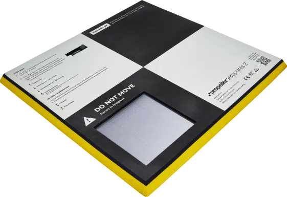
AeroPoints™ are high-precision, smart ground control points, thoughtfully designed for drone beginners, but precise enough for survey veterans. Forget hours with bases and rovers, just lay out your AeroPoints and let them do the work.
Use AeroPoints anywhere and with any coordinate system
Forget complex surveying equipment and prevent human error with these durable, lightweight ground control points.
One-button operation means you don’t need to be a GPS expert to use them. Just lay them out, and they’ll do their job.
AeroPoints upload their ground control data wirelessly to your user portal from whenever you are. Never worry about processing your own data again.
A dedicated AeroPoints app delivers real-time diagnostics about your ground control hardware and makes configuration setup a breeze.
How AeroPoints work
Each AeroPoint includes a solar panel and plug-in charger, battery, GPS, and Wi-Fi inside a fully-sealed, lightweight shell. The real value of AeroPoints comes from their flexibility—use them for ground control, checkpoints, or even as a base station.
There’s no more need for awkward and expensive survey gear. You can show up on site, quickly disperse the AeroPoints, and then fly.
Calibrate your AeroPoints with a permanent survey mark, including State Marks, by placing an AeroPoint over it and uploading the mark’s position with your data.
Ensure your drone data has the same reference point as your other data by importing a RINEX file with your AeroPoints. Great for construction sites with machine control.
Align drone data with machine control, design, and other site data by uploading your Trimble or Topcon calibration file to calibrate AeroPoints with your local grid coordinates.
Customer reviews:
Order AeroPoints
Get your set now to ensure your drone data is survey-grade
AeroPoints per set: x10
Maximum survey area per set: 70ha (180 acres)
Availability: In stock
Full Price: $8,000*
Order now5- to 7-day global shipping
30-day money-back guarantee
Instant credit card payments

2 AeroPoints bags
AeroPoints come in durable, hi-vis bag, making them easy to store and carry.
2 AeroStencils
AeroStencils make it simple to use AeroPoints to create semipermanent and permanent GCPs
AeroPoints processing
Every AeroPoint purchase includes 12 months of unlimited GCPs processing and corrections. After one year, it’s $600 annually for corrections and processing.
Hardware support
AeroPoints customers have access to our 24-hour chat support via the AeroPoints portal and email support during business hours (7am–5pm MST; 9am–5pm AEST).
AeroPoints Platform
View your ground control data visually. Keep track of placement, survey dates, and past data.


