


Ohio-based Sunesis Construction Uses Trimble Stratus for Tracking Earthwork and More
Before closing its doors, Ohio’s Cincinnati Gardens were best known for the Cincinnati Rollergirls, Xavier University basketball, and a variety of hockey games, concerts, monster truck shows, pro wrestling events, and indoor football and soccer matches..
Even in its final days, the iconic site continued to make headlines—this time as a proving ground for Sunesis Construction Company’s latest technology evolution. A heavy civil contractor based in West Chester, Ohio, Sunesis handles around 60 jobs per year, ranging in value from $100K to $15M.

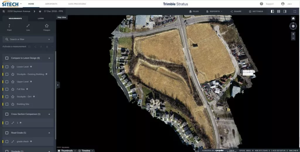
Sunesis to move 30,000 cubes on 19-acre site
After the Gardens were demolished, Sunesis was tasked with improvement work on the 19-acre site involving over 30,000 cubic yards of fill dirt and stormwater improvement. Ultimately, the Greater Cincinnati Redevelopment Authority will repurpose the site for light manufacturing.
Tracking earthwork quantities used to be a challenge
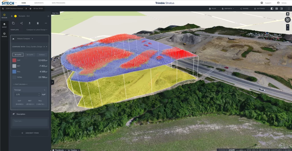
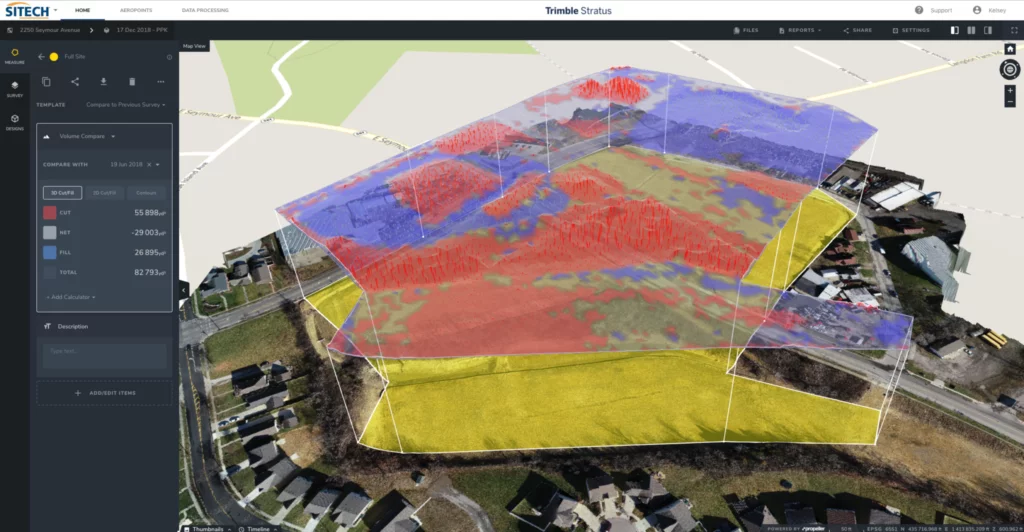
Jack N. Brown, machine control/3D data manager at Sunesis, says, “The challenge on any large project like this is estimating soil quantities.” This is especially true for a company like Sunesis, where all their earthwork is self-performed. “Following demolition, the parking lot had an unmeasured stockpile of soil on it and the building site was cut up from foundation. The design plans didn’t provide any measurable values either.”
Ordinarily, Sunesis crews would have used a GPS rover to measure around the stockpile and then estimate the building footprint. “It’s a tricky exercise to approximate soil quantities on a job this size—too low and we lose money, too high and we lose the bid,” Brown explains.
Instead, the company opted to test drone-enabled measurements with help from partner SITECH Ohio. SITECH provided a DJI Phantom 4 Pro to capture site data and Trimble Stratus powered by Propeller to get an accurate 3D site survey last summer. Trimble, the global leader in positioning technologies, was an early partner of Propeller. Our teams work closely together to deliver Trimble Stratus survey-grade drone data solutions for the heavy civil industries. Sunesis then upgraded to the Phantom 4 RTK and Propeller PPK workflow in December 2018.
“You can start working with Trimble Stratus almost immediately, even if you don’t have any prior experience, because it’s so easy to use,” says SITECH Ohio’s Joel Brown, a construction technology specialist who worked with Sunesis on the project. “Anyone can learn how to use it in 15 minutes.”
Once the site was flown, the data was uploaded and processed in Trimble Stratus, and then exported to Trimble Business Center.
Trimble Stratus makes calculating quantities easy
“Within a couple hours, I had the site survey data modeled within Business Center and was able to run calculations and determine quantities in order to create a bid for the client,” Brown says “We built the model and completed the job—the numbers were right on the money.”
Brown, who is also a certified remote pilot and manager of Sunesis’s drone fleet, used the drone-enabled data capture solution when the project was complete to confirm estimated site work quantities were accurate.
Sunesis expects more drone surveying, visualization software use on future projects
He sees the drone fleet getting extensive flight time in the coming years on highway, underground, water/wastewater, and environmental remediation projects. “We do a lot of public works projects that pay by quantity and require accuracy—drone-enabled measurement and mapping is the way to go,” he said.
Drones for site management will come in particularly handy this summer when the company begins work on a complex dam project in Kentucky that includes the rework of a spillway and step excavation.
“The real difference for contractors today is in the software,” said Joel Brown. “Improvements in visualization and analytics have helped turn drone-enabled site survey and mapping tasks into video game-like models. They have the tools to create immersive, measurable maps very quickly and easily—and that makes all the difference for contractors who need fast, accurate data.”