Project Tracking With Drone Data: How Site Surveys Keep Projects On Time and On Budget
Traditionally, earthworks professionals have surveyed both their small and large scale worksites on foot or by helicopter. Neither option is efficient, and both are costly. Drone surveys have changed all that, making it easy and affordable for site managers to survey construction projects more frequently, in some cases even as often as once per week. With traditional surveying methods, site managers would be fortunate to obtain survey data once a month, and even then the surveys would usually be outdated by the time they were complete. Now, drone surveys provide timely data to site managers and teams working on-the-ground alike, offering a host of benefits to all stakeholders involved with a project.
The adoption of construction progress tracking software is streamlining project workflows. Construction companies measure profitability in terms of how much material they move to or from a worksite. Tracking that movement can be challenging using traditional survey methods, as they are time-consuming and expensive. Implementing drone survey technology has changed the game, not just for teams working at a site, but also for investors and other project stakeholders.

Accessible and easy-to-understand progress tracking
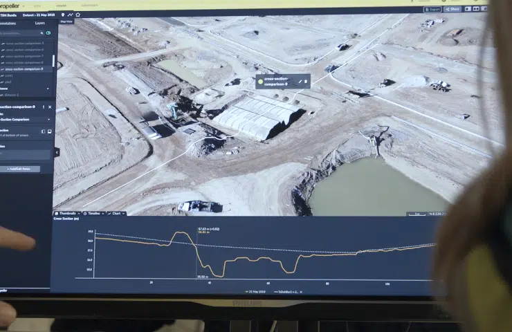
Drone survey software, like the Propeller Platform, processes site data to create effective 3D visualizations that everyone can understand. Survey teams initially survey a site to document and develop a 3D model of existing conditions on the worksite. They can then import a final grade, and the software calculates the true scope of the project in seconds. Frequent site surveys throughout the duration of the project provide up-to-date 3D models that give teams an accurate look at progress.
Detailed site maps generated by the Propeller Platform are accessible to anyone vested in the project in just a few clicks, not just surveyors and site managers.

Benefits of frequent progress tracking
Investing in a drone surveying program provides distinct advantages for construction and earthworks teams, throughout all stages of a project.
- Accessing more information: Surveying more frequently with a drone gives teams working on the ground, and other project stakeholders timely, more detailed, accurate information. This constant project monitoring allows project managers to communicate more frequently with management and helps them make decisions faster and more reliably, reducing project delays that can negatively impact operations.
- Ensuring accountability: 3D data gathered by a drone provides a single source of truth about the worksite from the beginning of the project onward. All project stakeholders, from investors to contractors to site managers have access to the same, accurate information to track progress and maintain accountability. Traditionally, project accountability could be challenging without the ability to refer to accurate site data. However, using drone survey technology allows for better cross-functional communication and each team clearly understands their responsibilities throughout the project lifecycle.
- Avoiding rework: Rework is not only time-consuming, often extending projects for many months, but it’s also expensive. Why spend extra time fixing a mistake that could have been caught early on with site data collected by drone? Rework consumes more time and reduces productivity which can negatively affect profitability—both in the short and long term. Rework on a project not only can result in lost revenue, it also can compromise a company’s credibility which can then jeopardize their ability to win future business. By frequently monitoring progress with drone surveys, project managers can identify problems faster, reducing the potential for rework and keeping projects on-time and on-budget.
- Providing documentation: Adopting a drone survey program can yield some legal benefits. Frequent surveys provide regular documentation of site conditions, and this information can be crucial in helping to resolve any project stakeholder disputes. With accurate drone survey data available, a visual record always exists to refer to, making it easy to audit the site to ensure work is completed as designed.
Drone data software is changing the way large-scale construction and earthworks projects are managed. By providing more data, more often, all project stakeholders have access to up-to-date information that drives good decision-making, boosts productivity, and minimizes rework. In short, adopting drone survey technology for your business is a smart investment!


