Legend Engineering Uses Propeller to Save Crew Time, Communicate with Clients as Part of Komatsu Smart Construction Initiative
Adopting new technology or tools into your business can be hard. But when you’re a small team, every minute counts and finding ways to do more with less is essential. When Lonny Reed, owner of Legend Engineering and professional engineer licensed in 20 states, was faced with a staffing shortage and strained resources, he sought […]
Adopting new technology or tools into your business can be hard. But when you’re a small team, every minute counts and finding ways to do more with less is essential.
When Lonny Reed, owner of Legend Engineering and professional engineer licensed in 20 states, was faced with a staffing shortage and strained resources, he sought to expand his toolbox with drone surveying.
Established in 2005, Legend Engineering performs topographic surveys and design for retail and industrial projects across the US, along with surveying and construction management. Based in Heber, Utah, it has about a dozen employees with two to four surveyors on staff at any one time.
Here’s where we’re going if you want to jump ahead:
The Challenge
Reed first heard about drones as a worksite tool when working with Komatsu’s Smart Construction initiative. “They’d use some of our sites as test sites to do drone surveying,” said Reed. “We knew that we needed to get into the drone survey world for a few years, and it never seemed feasible because of the amount of processing.”
When they had Part 107-certified drone pilots, they flew some test sites to process data using Pix4D. “We were getting ready to start [using] it on [project] sites, but without much confidence. Processing error and processing time was an issue,” recalled Reed. They were seeing errors of three or four feet, after an arduous time of processing data.
With time being a limited and valuable resource, self-processing was a bad fit for Legend Engineering.
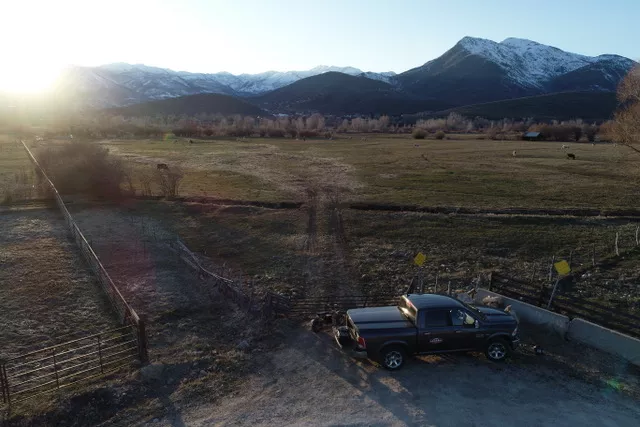
After one of his surveyors was injured during an on-site survey, Reed knew he needed a solution that worked to help with his surveying jobs. “He hurt his knee. He actually quit the surveying profession on us. We’ve had a terrible time trying to replace him,” said Reed.
Without one of Legend Engineering’s vital surveyors, Reed needed to use his team’s time as efficiently as possible. Work was piling up. Even for smaller, one- or two-acre sites, survey would take a whole day when you factored in travel time.
Before using drone surveying, man hours and crew time expended to get survey data was one of their bigger time sinks. “Being able to get out and do all the field work we needed with one field surveyor and one office surveyor—our field time was becoming the bottleneck,” Reed noted.
What Propeller Brought to the Worksite
Using drones to survey sites, the Legend Engineering team can now capture a survey in a couple of hours. With all that extra time, surveyors can also capture the boundary lines of a site, if needed.
Legend Engineering frequently surveys many small sites. So while the surveying itself can be done quicker than on larger sites, the team has to travel more often, which adds a lot of commute time to the average job.
With the time put back on the clock, Reed and his team can do more with the same resources. “What we’ll do is have our surveyors do the boundary, property lines, and set control for us. Then one of us will go out with the drone and pick up the rest of the information. That allows the surveyors to do their job and pick up more sites,” explained Reed.
Reed sees using drone surveying and Propeller as an aid to save time both in the field and in the office.
“If you look at it just from an office-time standpoint, you usually have someone in the office who you’re paying $20–50 per hour plus the software plus the processing time and all that,” said Reed. That’s just the baseline, and doesn’t include the cost it takes to capture good data.
Before using Propeller to process their data, Legend Engineering had at least one staff member doing the processing, which could take a day to a day and a half to complete.
“But uploading the drone photos to Propeller takes 20 minutes and then they can go about their day,” said Reed. With a small and nimble team like Legend Engineering’s, any time saved on administrative tasks has a big impact.
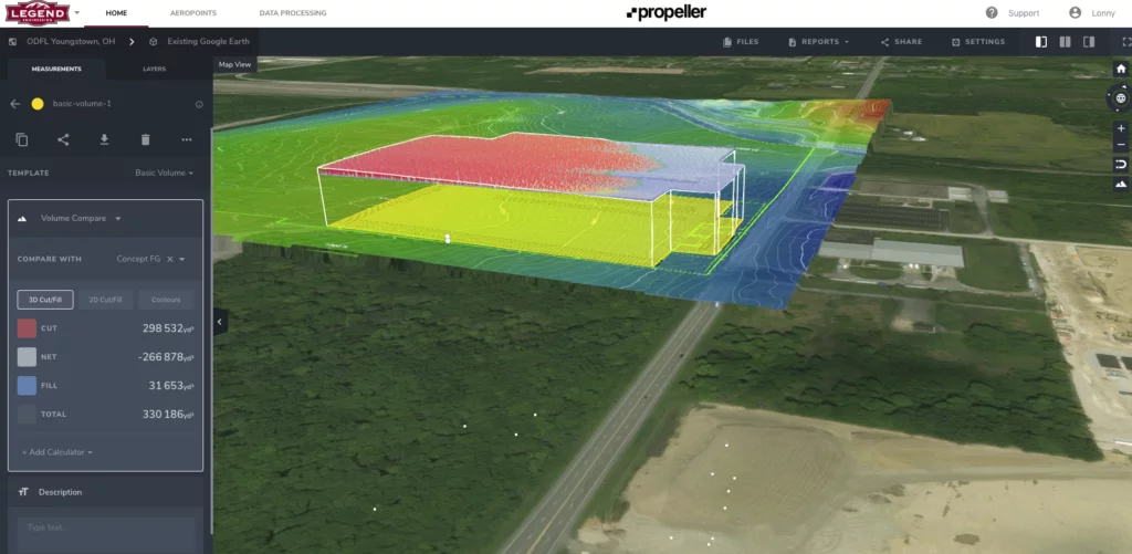
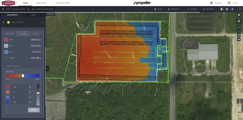
The potential for using drone surveying to collect data in the field and the Propeller Platform to process drone data and visualize it was huge. But Propeller also proved to be a tool to improve Legend Engineering’s communication with clients.
The Lasting Impact
Before Propeller, Legend Engineering ran client meetings with the conventional data and visualization—that is spreadsheets.
“From an engineer’s standpoint, that’s easy to look at and see what you’re dealing with. But for the contractor or client, it’s hard to see what’s going on there,” noted Reed. “Being able to see the color-coded map and rotate that [3D site survey] is a game changer for them.”
Old Dominion is Legend Engineering’s biggest and most important client. The company has a number of teams based around the country, and they recently adopted take-off software for preliminary work on a select group of projects.
When Reed and his team explained how they were using Propeller’s data and visualization software to work on their sites, “they were pretty excited,” noted Reed. After they built a few models to see what the software was capable of, they started using Propeller as a resource on weekly conference calls.
When you’re a small, agile team like Legend Engineering, the benefits of new technology can be felt quickly and keenly. Because there are fewer people to onboard, the integration process is smoother and the implementation can be immediate.
For Legend Engineering, using drones to survey their sites and Propeller to process and visualize data means they can cover gaps in staffing and save surveyor time—all while communicating better with clients and each other.
Want to share the Legend Engineering story with your team?
Plateau Excavation uses Trimble Stratus, powered by Propeller. Trimble, the global leader in positioning technologies, was an early partner of Propeller. Our teams work closely together to deliver Trimble Stratus survey-grade drone data solutions for heavy civil industries. Specializing in industrial construction, Plateau…
They say a picture is worth a thousand words. We think that’s especially true on busy worksites, but with a caveat: a picture is worth a thousand words if you know what you’re looking at. Without context (like where the photo was…
Developing an estimate for sitework can be a bit tricky. Bid too high, and you could lose the business to a competitor. Bid too low, and you could lose money on the project. After collecting information and getting a handle on the…
We’ll let you know every time we publish something new
Say hello to the Propeller Platform
Track, map, and measure active sites anywhere, anytime using cloud-based 3D surveys. Invite your whole team to join and collaborate from a one source of truth.
We use cookies on our website to give you the most relevant experience by remembering your preferences and repeat visits. By clicking “Accept”, you consent to the use of ALL the cookies.
This website uses cookies to improve your experience while you navigate through the website. Out of these, the cookies that are categorized as necessary are stored on your browser as they are essential for the working of basic functionalities of the website. We also use third-party cookies that help us analyze and understand how you use this website. These cookies will be stored in your browser only with your consent. You also have the option to opt-out of these cookies. But opting out of some of these cookies may affect your browsing experience.
Necessary cookies are absolutely essential for the website to function properly. These cookies ensure basic functionalities and security features of the website, anonymously.
Cookie
Duration
Description
cookielawinfo-checbox-analytics
11 months
This cookie is set by GDPR Cookie Consent plugin. The cookie is used to store the user consent for the cookies in the category "Analytics".
cookielawinfo-checbox-functional
11 months
The cookie is set by GDPR cookie consent to record the user consent for the cookies in the category "Functional".
cookielawinfo-checbox-others
11 months
This cookie is set by GDPR Cookie Consent plugin. The cookie is used to store the user consent for the cookies in the category "Other.
cookielawinfo-checkbox-necessary
11 months
This cookie is set by GDPR Cookie Consent plugin. The cookies is used to store the user consent for the cookies in the category "Necessary".
cookielawinfo-checkbox-performance
11 months
This cookie is set by GDPR Cookie Consent plugin. The cookie is used to store the user consent for the cookies in the category "Performance".
viewed_cookie_policy
11 months
The cookie is set by the GDPR Cookie Consent plugin and is used to store whether or not user has consented to the use of cookies. It does not store any personal data.
Functional cookies help to perform certain functionalities like sharing the content of the website on social media platforms, collect feedbacks, and other third-party features.
Performance cookies are used to understand and analyze the key performance indexes of the website which helps in delivering a better user experience for the visitors.
Analytical cookies are used to understand how visitors interact with the website. These cookies help provide information on metrics the number of visitors, bounce rate, traffic source, etc.
Advertisement cookies are used to provide visitors with relevant ads and marketing campaigns. These cookies track visitors across websites and collect information to provide customized ads.