How Haskell Uses Propeller to Manage Contractors on a Complex Worksite
Haskell provides engineering, design, and building solutions for industrial, commercial, government, and civil infrastructure markets. Their customers come from a large variety of industries and operate in North America, Latin America, Europe, and the Caribbean.
![]()
Background
Haskell, a company providing engineering, design, and building solutions for industrial, commercial, government, and civil infrastructure sectors, uses a variety of subcontractors to help with their projects. Managing the quality and progress of individual subcontractors’ work, and verifying it meets design specification, is critical to staying on schedule and avoiding conflicts.
Challenge
Hamzah Shanbari was part of the Haskell team working on a massive construction project that had him coordinating the work of dozens of subcontractors. As a technology and innovation manager for Haskell, he was in charge of ensuring subcontractors placed critical infrastructure in the right places. Base-and-rover surveying wasn’t feasible here due to the speed of construction. He needed to survey the whole site, once or twice a week, every week.
Solution
Propeller’s drone-mapping and analytics solutions gave Haskell the power to measure and manage the work on site, with visual tools everybody could use anywhere, from any device. Propeller helped teams work together better to understand progress on site in comparison to construction models and schedule.
Using drone-captured data and Propeller, Haskell could visualize twice-weekly surveys—and track subcontractors’ progress and productivity quickly and easily. Regular, up-to-date surveys of the site allowed the team to make better informed decisions, reduce costs, improve quality, and deploy resources more efficiently.
Results
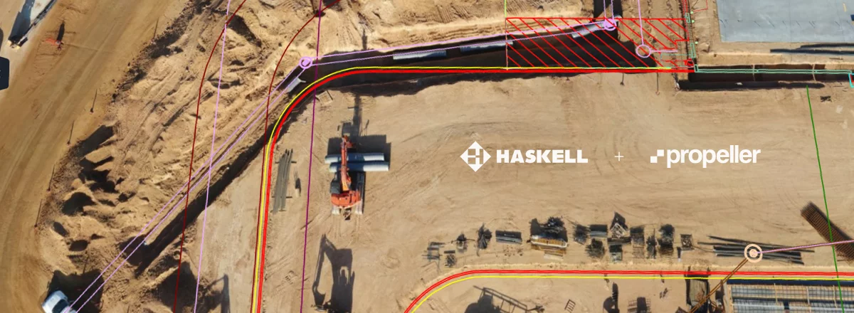
In Propeller, Haskell could view and compare 3D site imagery to design files showing various stages of the project, including those prepared by subcontractors. By overlaying the 3D surface with the design file, they could see whether or not work was going to plan and manage any issues quickly. “Propeller helped us recognize issues with the work our subcontractors were doing and correct them before they became expensive,” said Shanbari.
The importance of having such information became obvious when checking the work of the underground services contractor—who was running conduit below ground—in the Propeller Platform. Comparing the model of the conduit to the survey of the subcontractor’s work area, the team realized the conduits were placed at a different location and depth than what was modeled. Further, the conduits would interfere with an eight-inch pipe being installed by another subcontractor.
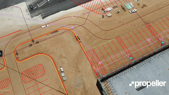
Armed with this information, the team showed how the subcontractors were off in their conduit placement, thus proving they needed to correct the work or update the model to reflect as-built conditions.
In the end, the subcontractor modified the model to avoid rework, but more importantly, the coordination team identified the issue before the plumbing subcontractor started laying pipe that would conflict with the conduits. The plumbing model was also adjusted to account for the new location and depth of the conduits.
“Propeller makes it easy for us to monitor the work happening on the worksite and make sure everything is being done as designed and modeled. The level of visibility drone surveys provide allow us to identify issues quickly and before they become expensive problems. If I was to describe Propeller in one word, it’d be ‘fantastic’,” said Shanbari.