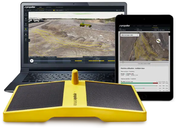
Daily Volumes on Demand
Improve daily productivity tracking with survey-grade machine sensors
Learn More
Drive productivity at every level, across multiple teams.
DirtMate is an easy-to-install, cost-effective machine tracking system that integrates seamlessly with high-accuracy drone data to give you up-to-date volumes and productivity data every day.
DirtMate provides quick access to a reliable source of truth that can be used to resolve disputes, drive productivity, and understand exactly how you’re pacing on a daily basis.
Easy access to daily earthworks volumes
Collect high-accuracy (5cm) surface data from the machines running on site to generate daily volumes. No more blind spots and no more guesswork. Know exactly where you’re at, every time you get to work.
Any machine, any manufacturer
It doesn’t matter what machine control system you’re using, what make or model of machine you’re working with, or even the age of your machine. DirtMate is compatible with all earthmoving machines.
Comprehensive machine usage tracking
Gain full visibility over which machines are working, where, and when. Pinpoint their location in real-time and observe how they operate as a fleet.
Holistic, up-to-date picture of your site, every day
Combine DirtMate with high-accuracy survey data to gain a holistic, up-to-date picture of your site that you’ll use to generate daily volumes, cut and fill heatmaps, and progress-to-design measurements within the Platform.
How DirtMate works
Position (X,Y,Z)
Orientation
Mounting
Power
Communication
GNSS corrections source
How is DirtMate already helping worksites?
See how Suez are using DirtMate to track daily volumes and machine productivity.
Watch videoEasy access to daily earthworks volumes
All your progress data in one place
Use up-to-date surface data to generate daily volumes, cut and fill heatmaps, and progress-to-design measurements within the Propeller Platform.
Avoid disputes and build trust through transparency and detailed usage records. Leverage complete ‘source of truth’ documentation, accessible anywhere, anytime.
Automated insights to understand your progress status
The tablet-friendly DirtMate Dashboard gives everyone on site easy access to automated insights that can be used to understand the current status of daily volumes, driving productivity at every level, across multiple teams.
- Machine utilization data across the fleet
- Machine location tracking and history
- Weather reports


