How DirtMate and Propeller Platform Deliver a Complete View of Your Worksite and Operations
Construction once lagged behind most industries in tech adoption—but over the past decade, contractors have been catching up. In fact, 98% of engineering and construction companies now agree that digital solutions are critical to the viability of their business over the long run.
An increasing number of contractors now rely on drone surveys to give them frequent insight into what’s happening on a worksite: calculating cut/fill, scoping material volumes, tracking progress against design, etc.
But even frequent drone surveying can leave some questions to be answered. Questions like: what’s happening on my worksite right now?
DirtMate is the key to filling in those gaps. When you fly your drone, you see what’s changed from week to week or flight to flight. DirtMate gives you access to up-to-date surface data every 30 minutes and machine usage data nearly real-time.
With DirtMate, you can collect data from all of your machines and sync it with the most recent drone survey for a holistic view of your worksite. You’ll get more or less the same data you’d get from a drone survey—but without waiting to get a drone in the air.
Read on to learn how DirtMate works with the Propeller Platform to provide a seamless, up-to-date picture of your worksite.
What is DirtMate?
DirtMate is an easy-to-install and cost-effective machine tracking system that’s unrivaled in the industry. With DirtMate, you get updated material volumes and productivity data every half hour from any device, so you can ensure your projects stay on track.

DirtMate provides up-to-date . . .
- Daily Progress (volumetrics)—accurate, 3D surface elevation data that’s compatible with Propeller’s progress measurement tools
- Machine Utilization information for your fleet on site
- Field Operations to Office tracking and insights—machine location tracking, including location history
Why manually pull surface data from your dozers and load it into Propeller when DirtMate makes the process much smoother, with automatic updates every 30 minutes? With direct integration into the Propeller Platform, DirtMate updates your drone surveys with the latest surface data from your dozers, saving you the time and hassle of cross-referencing two distinct data sets.
TL;DR: DirtMate makes it easy to fill in the gaps between drone surveys.
How it works
While it’s possible to manually input equipment data into Propeller with a machine control system or telematics, you’re faced with a lot of labor to get the data you’re looking for: welding six-foot masts to each machine, attaching expensive GPS units on either end, and removing those units daily so they don’t go missing.
The process to measure and manage the data that comes back from these systems is no walk in the park, either, so you need dedicated expert resources to ensure your data is accurate.
DirtMate makes that entire process simpler and less expensive.
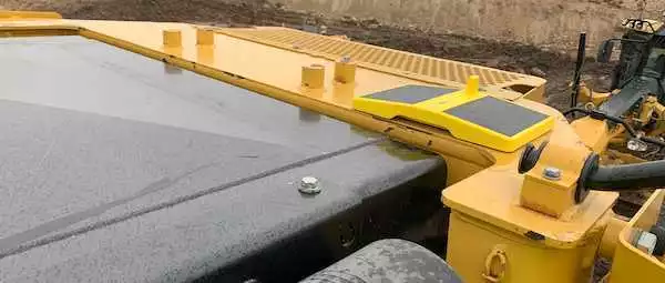
- Magnetically mounted: Just place a DirtMate device on the roof, input three simple measurements into a mobile app, and go. DirtMate devices are easy to remove at the end of the day—but low-profile enough that you may decide not to bother.
- Survey-grade GPS: Like an RTK drone, DirtMate has built-in survey-grade GPS, but without the hefty price tag.
- Solar-powered: Powered by the sun, or chargeable through a power cable for those days when solar doesn’t cut it.
- Brand-agnostic: DirtMate doesn’t care what equipment you’re using; it works on any piece of machinery regardless of who made it. All of your data will feed into the Propeller Platform automatically.
- RTK technology: DirtMate uses RTK (real-time kinematic) processing, the same technology used to power survey drones. Any unit can serve as a base station; there’s a divot in the middle for a rover. Simply shoot a known point and use that DirtMate device as the base station.
- Survey-grade accuracy: Just like Propeller PPK, DirtMate achieves survey-grade accuracy—the best possible accuracy recorded from work equipment.

Understand the “why” behind your worksites
Drones tell you What is happening on your worksites and when. DirtMate fills in the gaps by telling you Why.
For example, DirtMate doesn’t just record surface elevations; it also tracks machine vibration to record inertial measurements. If a machine isn’t vibrating, DirtMate knows it’s off. If it’s vibrating but isn’t moving, it’s idling. DirtMate tracks idling time to help identify on-site inefficiencies, so Project Managers can add or reallocate equipment based on idle time.
Here are four ways that tracking your equipment with DirtMate keeps your production reporting up to date:
- Every machine reports elevation data, regardless of OEM, GPS-equipped status, or age
- Machine and drone surfaces are automatically combined with the most recent data for a full site report
- DirtMate continuously produces new surfaces for your project (every half-hour)
- Everyone has access to the results right away, with no need to wait for processing or consult an expert
Drones reduce discrepancies in your survey data. DirtMate eliminates them. Request a demo to learn more.


