From Simple Drone Surveys to Worksite Management (Part Two)
Propeller + Trimble
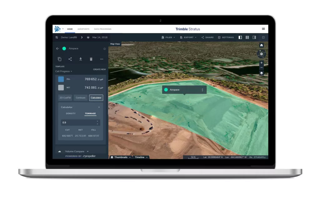
Integrated Sustainability is using Trimble Stratus, powered by Propeller. Trimble, the global leader in positioning technologies, was an early partner of Propeller. Our teams work closely together to deliver Trimble Stratus survey-grade drone data solutions for the heavy civil industries.
You can check out the first part of our comprehensive case study with Integrated Sustainability here.
Rethinking the role of the construction manager
Starting off as a niche engineering consulting firm for efficient water, waste, and renewable energy projects, Integrated Sustainability has evolved over the last nine years into a specialty turnkey infrastructure development company, offering development and engineering design, construction execution, and operations services.
By uniting each aspect of the construction process into one business model, Integrated Sustainability is able to offer their customers a one-two punch value proposition of cost control and risk reduction. Basically, their industry expertise and deep knowledge of sustainable best practices gives them a competitive advantage.

For a full-service contractor like Integrated Sustainability, maintaining visibility on all the moving parts of every project is a particularly difficult task. That’s why they entrust the oversight of their sites to a veteran construction professional like Gary Smolik.
Gary’s duties are wide-ranging and include estimating and planning jobs, sourcing equipment, communicating with his site managers out in the field, validating data, and much more. Gary also contributes to the business development side of Integrated Sustainability, updating and maintaining relationships with current clients, and pitching to potential customers as well.
Having someone with Gary’s institutional knowledge preaching their value props directly to clients is a huge asset. To give Gary more face time with their customers, Integrated Sustainability needed a solution to make the operational side of Gary’s job easier.
Integrating drone surveys into the construction manager workflow
In the office, Gary works alongside Geomatics Manager, Kris Kwiatkowski. It’s Kris’s job to verify survey data and provide Gary with the insights he needs to understand progress on the ground and make logistical decisions.
Recently, Kris began using Propeller PPK, an end-to-end drone surveying workflow that accelerated and improved the accuracy of his data collection, and provides him with interactive, actionable 3D site models within 24 hours. Thanks to Propeller, Kris is spending a lot less time processing and interpreting survey data. He also now has access to a suite of in-platform measurement tools that has streamlined his ability to calculate the volume of stockpiles and pits, track earthworks over time, and compare progress to design.
While the benefits for Kris are obvious—more surveys, in less time, with the same level of accuracy—he hoped access to faster, accurate progress data could aid everyone in their organization, starting with Gary. The goal was to make it easier for Gary to:
- more quickly provide on-site teams with the information they need to work more efficiently and avoid rework.
- maintain visibility on whether projects’ progress and budget, enabling him to make decisions further in the future.
- tighten up operations, furthering Integrated Sustainability’s mission to perform work with minimal environmental impact.
The difference daily drone data makes
When Integrated Sustainability switched to daily drone flights, Gary was suddenly getting progress data at a frequency he had never had before. Every morning, Gary is able to inspect 3D models of his worksites based on the survey data their drone pilot gathered the day before, using the platform’s industry-specific measurement tools to check the state on the ground.
With these daily insights, Gary is empowered to make more decisions on his end: When do subcontractors need to be scheduled for the next stage of a project? How many resources are necessary to execute remaining work? What can be done to make daily operations more efficient?

During our discussion, Gary was able to point to two specific examples where access to more timely data resulted in saved time and money.
In one instance, site teams told Gary they were preparing to move material across the site to fill in a hole. Within 15 minutes of learning this, Gary was able to have Kris check the previous day’s progress against their final design. Seeing they still had thousands of square feet worth of material to excavate before they were ready to move on to that next stage of the project, Gary directed his site manager to reverse course, preventing costly rework.
Being able to check quantities in real time turned what would have taken five or six resources and half a day or longer into a fifteen-minute operation.

In another case, while performing Quality Assurance for another contractor, Gary’s team suspected that dirt was being incorrectly excavated. To confirm their suspicions, they sent out their drone pilot to fly the site. After receiving their site map back 24 hours later, Kris overlaid it with the design linework and figured out that a berm had been removed from their plans and site teams were digging directly into it.
Had they not caught that, Gary suspects the contractor would have had to perform more than half a million dollars worth of rework.

The lasting impact
Kris, as the primary user of the drone data, is on a mission to increase the integration of Propeller into Integrated Sustainability’s operations. The goal is to upgrade Propeller from a simple drone survey tool to a unified worksite management solution within their company. Slowly but surely, he wants to get a more diverse set of team members onto the platform, and start figuring out ways to utilize drone data during every stage of a project.

Gary has been a primary beneficiary of Kris’s drive to embrace the full potential of drone data. As demonstrated above, he’s already been able to use access to quick, verifiable quantities to keep his sites running more smoothly and with greater confidence. And as Kris continues to explore how to leverage drone data and the platform, Gary’s operational work will surely become more streamlined as well.
While Gary describes himself as an old-school guy, saying a year ago he was “barely able to turn on a computer,” his relative technological inexperience hasn’t proven to be a deterrent when it comes to the Propeller workflow. That ease of use will likely make Kris’s mission to unify operations around the platform even easier.
Want to see how Propeller works? Unlock a demo here.
Keep reading:
A Case Study: The Journey From Simple Drone Surveys to Worksite Management (Part One)
Colorado’s Zak Dirt Generates Fast, Accurate Topos for Highway Project


